A Locality Guide to Bannerghatta Road
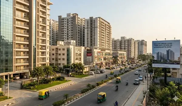
Write about Bannerghatta Road and most accounts cover roughly a third of it: the stretch a city commuter uses, Dairy Circle to Jayadeva, past IIM Bangalore, as far as the Outer Ring Road, and there they stop. The road runs a long way further, and it is out there that new low-density housing in south Bangalore is actually being built. This guide follows the corridor end to end and describes how it changes as it goes south, because the character of the road at kilometre five and at kilometre thirty is not remotely the same thing.
For a buyer the point is straightforward: a corridor is not one market. Price, plot size, traffic, greenery, water supply and the kind of development you find all change as you move along it, so a claim that holds at Arekere can be nonsense at Bannerghatta. Which segment a project falls in tells you more than any headline figure about the road as a whole.
What Bannerghatta Road Actually Is
Formally it is State Highway 87, a Karnataka state highway roughly 45 km long. It branches off Hosur Road at Adugodi, near the Adugodi Christian cemetery, then runs south through Bengaluru's southern suburbs to Bannerghatta and Jigani, continuing as the Jigani–Anekal road and ending at Samanduru in Anekal taluk near the Tamil Nadu border. Depending on the segment, maintenance falls to the Karnataka Public Works Department, the Bangalore Development Authority or the BBMP, part of the reason road quality is not uniform along it.
The corridor is defined by three junctions. At its northern end it meets Hosur Road at Adugodi. Further south it meets the Outer Ring Road at the Jayadeva Hospital interchange, where the two briefly run together before diverging again. And it crosses the NICE Road near Gottigere, the point at which a driver can leave the corridor westward toward Mysore Road and the Bangalore–Mysore corridor without re-entering the city. On the northern half, two grade separators, the Dairy Circle underpass and the Jayadeva underpass, carry through traffic under the two worst intersections.
The Inner Stretch: Adugodi to Jayadeva
Picture Bannerghatta Road and this is the segment that comes to mind. It is dense, fully built out, and institutional rather than residential in feel. The Jayadeva Institute of Cardiovascular Sciences is here, along with a cluster of large private hospitals, Christ University's campuses, IIM Bangalore, and a continuous frontage of offices, showrooms and retail. Housing means old apartment stock and older independent houses on small plots, and land does not come to the market in any meaningful size.
The corridor's reputation rests on the traffic here, and it is deserved. The road narrows in places, the side roads feeding it are residential, and the hospital cluster generates all-day rather than peak-only movement. The underpasses help; they do not solve it. Before assuming anything about their own commute, anyone buying further south should drive this segment at 9.30 on a weekday morning.
The Middle Stretch: Jayadeva to Gottigere and the NICE Road
Past the Outer Ring Road the road opens up. The neighbourhoods here, Arekere, Hulimavu, Bilekahalli and Gottigere, belong to Bengaluru's suburban expansion of the last two decades rather than to its old core. Mid-market apartment supply on the corridor is concentrated here, so are the malls and the larger supermarkets, and it was south of the Jayadeva crossing that the road was widened under a public-private arrangement. Organised retail clusters along this stretch: measured from Bilwaradahalli on the southern reach, Royal Meenakshi Mall at Hulimavu is 7.5 km, Nexus Vega City Mall 11.2 km, and Forum South Bengaluru and Elegance Mantri Mall, also written "Mantri Elegance", 11.6 km each. The hospital cluster occupies the same middle-to-inner stretch, with Fortis at 10.1 km and Apollo at 10.9 km from that same point.
Where the corridor crosses the NICE Road near Gottigere is where the built city practically ends. To the north you are in a suburb. To the south the frontage begins to thin, the plot sizes get bigger, and the pattern of development changes from apartment blocks to gated layouts and villa communities.
The Southern Reach: Bannerghatta, Bilwaradahalli and Jigani
Beyond the NICE Road the corridor runs toward Bannerghatta National Park, and the landscape changes with it: continuous urban frontage gives way to villages, farmland, wooded patches and the park's buffer country. Development turns discontinuous, gated communities and layouts separated by open land rather than a solid ribbon of building. This is the segment Bilwaradahalli belongs to, and with it Nambiar Beverly Green, roughly 3 km from the Bannerghatta Nature Camp run by Jungle Lodges and Resorts. Gottigere is the postal head office and the pin code is 560083.
South of that the road passes Jigani, which is an industrial area rather than a residential one, and continues as the Jigani–Anekal road toward Anekal town and eventually Samanduru. That industrial character is worth registering, because it puts commercial vehicle traffic onto the southern half of the corridor that the residential stretch would never generate on its own.
What Actually Changes as You Go South
Density and plot size
This is the clearest gradient of the lot. Apartments on small footprints along the inner stretch; larger apartment projects in the middle; and on the southern reach, the only land parcels big enough for a villa community at all. That is why villa formats appear there and essentially nowhere closer in.
Green cover
Approaching a national park makes the southern reach genuinely wooded in a way no inner Bengaluru suburb is. That is a real amenity, and it is equally the reason land use there is more tightly watched.
Infrastructure maturity
On the inner stretch, water supply, sewerage, street lighting and last-mile road quality are all city-standard; they fall away progressively as you move out. Out on the southern reach, ask three specific questions: what a project's water source is, how sewage is treated, and who maintains the approach road from the highway to the gate.
Public transport
BMTC service gets thinner the further south you go, so the pattern matters more than any single distance to a stop. On the southern reach, a stop can be a two-minute walk from a gate and still barely run. Bilavaradahalli Cross, 190 m from the Nambiar Beverly Green gate, is the example:
- Around fourteen buses a day, the first at 5:51 AM and the last at 7:04 PM, so there is nothing home in the evening.
- The frequent routes to Majestic leave from Bilavaradahalli (1.5 km) and Bannerughatta Circle (2.3 km) instead.
- The KIA-14A to the airport starts from Bannerughatta Circle.
Timings are as shown on Google Maps in July 2026, and BMTC schedules change, so check the live departure board at mybmtc.karnataka.gov.in before you set out. Wherever you are looking on this corridor, ask about frequency and the last bus, not just how close the stop is.
The corridor is also getting Namma Metro’s Pink Line; its southern terminus is Kalena Agrahara on this road, so the middle stretch feels the change first. The line is under construction and not yet carrying passengers. The elevated Kalena Agrahara to Tavarekere section had a 15 August 2026 opening date, but Deccan Herald reported in July 2026 that it would miss it and is now expected in late August or early September, with signalling validation still to be completed before the statutory safety inspection. Check the current position with BMRCL. For the southern reach, that terminus is 6.3 km away and still closed; the nearest station running today is 12.5 km away on the Green Line, at Yelachenahalli or Silk Institute.
Reading the Corridor Before You Buy
No locality article, this one included, is worth as much as three habits. Drive the full length of your intended commute, in both directions, at the hour you would actually make it. Check the guidance values and registered transaction records for the specific village or survey area rather than the corridor average, Karnataka's Kaveri Online Services shows what property nearby has actually changed hands for. And treat every drive time you are quoted as unverified unless you have driven it yourself. Every distance this page gives for the project, the two metro figures and the three BMTC stops, is on record and measured; the full set is on the connectivity page.
Where Nambiar Beverly Green falls on this corridor, and what is around it, is covered on the Nambiar Beverly Green location page. Further corridor and buying guides are indexed on the Nambiar Beverly Green blog.
Explore Nambiar Beverly Green