Nambiar Beverly Green Master Plan
The Nambiar Beverly Green Master Plan is drawn across 36 acres of Phase 1 within a 76-acre development, at Bilwaradahalli on Bannerghatta Road in south Bangalore, 298 villa plots, six landscaped parks, 12 m internal roads and an entrance plaza with a bus bay. Layout detail and plot mix follow below.
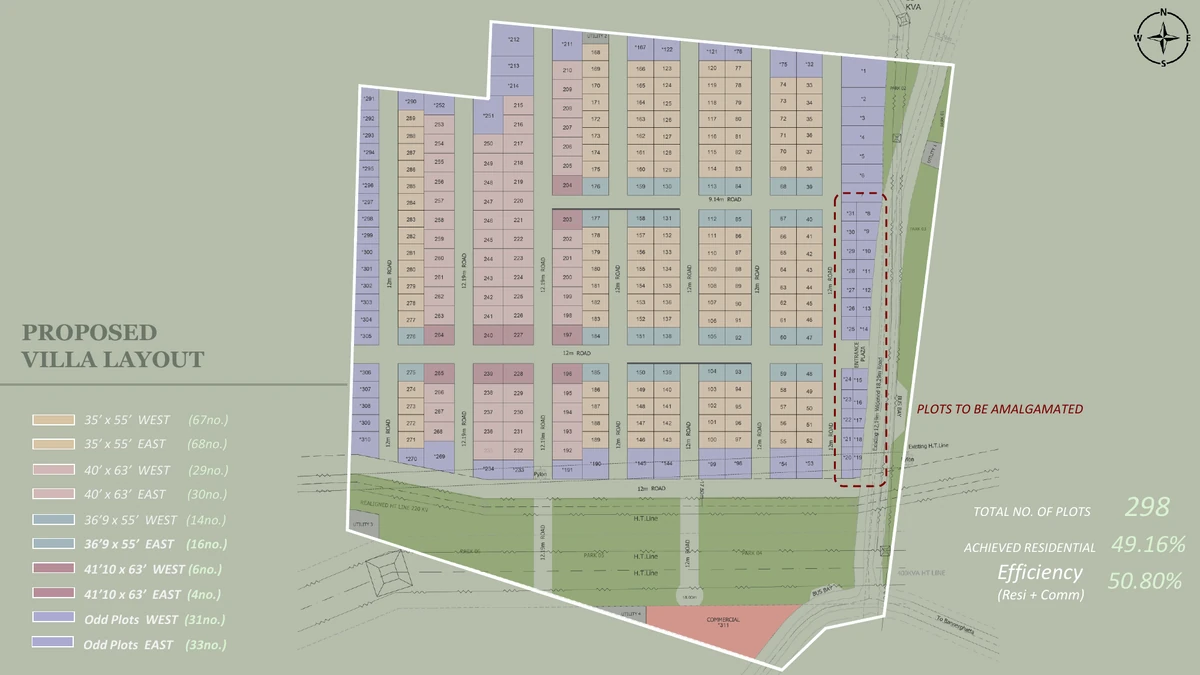
A 76-acre development at Bilwaradahalli on Bannerghatta Road is what the Nambiar Beverly Green master plan covers; the 36 acres drawn up so far are Phase 1. Within them are 298 villa plots, set along a hierarchy of 12 m and 12.19 m internal roads with 9.14 m secondary roads, and edged to the south by six landscaped parks. A single entrance plaza takes all vehicle entry and carries a dedicated bus bay and a small retail and commercial block as well. About half the land is villa plots; the rest is roads, parks and open space.
No plot is sold bare: each comes with the villa built on it, a G+2 house with a private lift, four bedrooms and a terrace-level second floor level. What the master plan governs, then, is the land parcel, the roads, the parks and the services. The house itself is set out on the villa plans.
- 76 acres in total; Phase 1 covers 36 acres
- 298 villa plots in Phase 1
- Six landscaped parks along the southern edge
- 12 m and 12.19 m internal roads, 9.14 m secondary roads
- Entrance plaza with a dedicated bus bay, and a retail and commercial block at the gate
- About half the land is villa plots; the rest is roads, parks and open space
In detail: the Phase 1 layout works through the drawing area by area; the plot mix sorts the 298 plots by size and facing; and setbacks and building envelope traces how a plot dimension turns into a buildable house.
Phase 1 Development Plan
The Phase 1 development plan offers 298 plots in several sizes rather than one. Two footprints dominate, the 35 × 55 and the 40 × 63, joined by two slightly wider variants and a set of odd-shaped parcels where the layout runs into the boundary. Because east- and west-facing counts are close to even in every size, orientation is a real choice here and not a queue.
| Plot size | Plots | West facing | East facing |
| 35 × 55 | 135 | 67 | 68 |
| 40 × 63 | 59 | 29 | 30 |
| 36'9" × 55 | 30 | 14 | 16 |
| 41'10" × 63 | 10 | 6 | 4 |
| Odd plots | 64 | 31 | 33 |
| Total | 298 | 147 | 151 |
Roads and Movement
For a villa layout, 12 m and 12.19 m is a wide section, with 9.14 m secondary roads taking the shorter runs between plot clusters. The width buys room for two-way movement, on-street visitor parking and a planted verge at once, so the road does not become a bottleneck once the houses are occupied. Everything enters the phase through the entrance plaza, which also holds a dedicated bus bay so that school and staff transport can pull off the main road rather than halting on it.
The Six Parks
Six landscaped parks line the southern edge of the layout: a green frontage for the plots on that side, and somewhere to walk to for the rest of the phase. What the master plan actually shows is the parks themselves. No overall open-space percentage has been published for this project, so none is claimed here, and nothing has been released about their planting schedule, play equipment or any structures built within them.
The Retail Block at the Gate
Convenience retail belongs at the gate rather than inside the layout, and the placement here is deliberate: the shops face the main road, so delivery and customer traffic never has to pass the houses. The retail and commercial block is planned at the entrance. Neither its tenant mix nor its built-up area has been published.
The Clubhouse on the Master Plan
One shared building has been confirmed by the developer: a 60,000 sq.ft. clubhouse, including a duplex and indoor amenities. Size, duplex, indoor provision, that is the entirety of what has been released. The schedule of facilities inside the clubhouse has not been released, which means no pool, gym, sports court, indoor games room or jogging track is on record for this project, and none is drawn on any plan carried on this site. Two questions are worth putting in writing: which phase the clubhouse falls in, and when it completes. Phase 1 is 36 acres of 76, the developer's stated project completion date is 31 December 2030 and possession is stated for 15 January 2031, so whether the club arrives with the first villas or the last is a fair thing to ask. And be sceptical of any facility list you are shown that matches Nambiar District 25's: that clubhouse is 3,00,000 sq.ft. and serves apartment towers, five times the size of this one, and none of it belongs to this project. The amenities page sets out what is on record and what is not.
The 220 kV Line on the Southern Boundary
Along the southern boundary of the development runs a 220 kV high-tension line, realigned to that edge. Before choosing a plot on that side, buyers should see the realigned route on the sanctioned layout plan and confirm the statutory corridor width and the setback of the nearest plots. The approved plan is public record on this point; ask for it in writing.
What the Master Plan Governs on Each Plot
The margins come from the Karnataka Gazette, Part-IVA, Table 8 for plots of 150–250 sq.m: 1.0 m at the front, 0.8 m at the rear and 0.8 m on each side. Work within them over three levels and a 1,925 sq.ft. plot carries a 3,732 sq.ft. built villa, while a 2,520 sq.ft. plot carries 4,627–4,638 sq.ft.
Approvals
No registration number has been allotted and the project is pre-launch: K-RERA registration for this project has been applied for; approval is expected by 20 August 2026. Once it is granted, the sanctioned layout plan, plot dimensions and land use filed with K-RERA become the legally binding version of everything on this page. Check status at rera.karnataka.gov.in.
Frequently Asked Questions
1. How large is Nambiar Beverly Green and how much of it is Phase 1?
76 acres at Bilwaradahalli on Bannerghatta Road make up the master development. Phase 1 is the portion drawn up so far: 36 acres holding 298 villa plots. Nothing has been detailed publicly about the later phases.
2. What plot sizes does the master plan lay out?
Two principal footprints carry most of the 298 plots, 35 × 55 (1,925 sq.ft. of land) and 40 × 63 (2,520 sq.ft.). Smaller groups, plus 64 odd-shaped plots at the layout boundary, make up the rest.
3. How wide are the internal roads?
12 m and 12.19 m for the internal roads, and 9.14 m for the secondary roads that take the shorter runs between plot clusters. Entry is through a single entrance plaza, which also carries a dedicated bus bay.
4. What open space does the master plan show?
Six landscaped parks along the southern edge of Phase 1. Since no overall open-space percentage has been published for this project, none is quoted here; the parks and the road network are what the master plan itself shows.
5. There is a high-tension line on the boundary, where exactly?
Along the southern boundary of the development, where a 220 kV line has been realigned. Ask for the sanctioned layout plan showing the realigned route, then confirm the statutory corridor width and the setback of the nearest plots before selecting a plot on that edge.
6. What setbacks apply to each plot?
1.0 m at the front, 0.8 m at the rear and 0.8 m on each side, per the Karnataka Gazette, Part-IVA, Table 8, for plots of 150–250 sq.m. The villa design is already drawn within those margins.
7. Is the layout K-RERA registered?
Not yet, the project is pre-launch, with K-RERA registration applied for and approval expected by 20 August 2026. After registration, the sanctioned layout plan and land-use filings on the Karnataka RERA portal become the binding version of this master plan.
Explore Nambiar Beverly Green